- About MAA
- Membership
- MAA Publications
- Periodicals
- Blogs
- MAA Book Series
- MAA Press (an imprint of the AMS)
- MAA Notes
- MAA Reviews
- Mathematical Communication
- Information for Libraries
- Author Resources
- Advertise with MAA
- Meetings
- Competitions
- Programs
- Communities
- MAA Sections
- SIGMAA
- MAA Connect
- Students
- MAA Awards
- Awards Booklets
- Writing Awards
- Teaching Awards
- Service Awards
- Research Awards
- Lecture Awards
- Putnam Competition Individual and Team Winners
- D. E. Shaw Group AMC 8 Awards & Certificates
- Maryam Mirzakhani AMC 10 A Awards & Certificates
- Two Sigma AMC 10 B Awards & Certificates
- Jane Street AMC 12 A Awards & Certificates
- Akamai AMC 12 B Awards & Certificates
- High School Teachers
- News
You are here
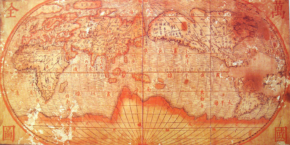
Mathematical Treasure: Matteo Ricci’s World Map and the Zhifang Waiji
Among the contributions of the Jesuit missionary Matteo Ricci (1552–1610) to the Chinese Ming Court was a world map. The Kunyu wanguo quantu, or Map of the Ten Thousand Countries of the Earth, is the oldest surviving map in China to depict the Americas. It is a xylograph (wood block print) on six panels of fine native paper (made with bamboo fiber). Ricci was assisted by translator and engraver Zhizao Li (1565–1630) and printer Zhang Wentao. This map was completed in 1602 and represents the world as then known by Europeans but completely unknown by the Chinese. As an honorary concession to his Chinese hosts, Ricci drew China as the central reference point. One of the few surviving copies is owned by the University of Minnesota. In the 1620s, Giulio Aleni (1582–1649) prepared the version of the map shown here (retitled Wanguo Quantu, or Complete Map of the Myriad Countries).
The Ming Emperor then asked other missionaries to prepare an atlas describing and explaining the new countries, which was completed in 1623 by Aleni and Yang Tingyun as the Zhifang Waiji.
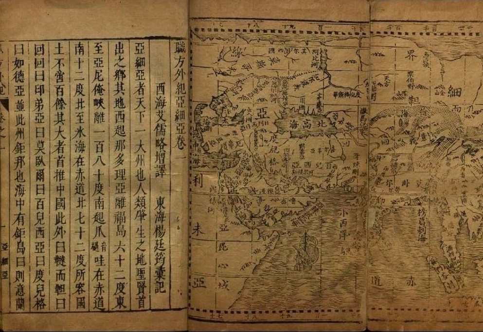
These images are available from Wikimedia Commons (Kunyu wanguo quantu and Zhifang Waiji).
Frank J. Swetz (The Pennsylvania State University), "Mathematical Treasure: Matteo Ricci’s World Map and the Zhifang Waiji," Convergence (December 2022)


